Cutting-Edge Drone Technology Revolutionizes Land and Water Mapping
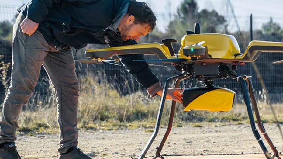
Imagine standing by a serene river, watching a drone glide effortlessly overhead. This is not just a scene from a futuristic film; it’s a reality with YellowScan’s innovative Navigator system. This advanced technology harnesses lidar systems to meticulously map both land and shallow waters, offering unprecedented accuracy in environmental monitoring.
Transforming Environmental Research
The Navigator is a game-changer, particularly for researchers and conservationists striving to understand and monitor the dynamic nature of our planet’s waterways. Unlike traditional mapping methods that often fall short, this system provides a fresh perspective on environmental changes.


Introducing the Navigator System
Weighing in at approximately 8.16 pounds, the Navigator is designed to integrate seamlessly with professional drones. Under optimal conditions, it can map shallow water depths of up to 65.6 feet, generating digital models with an impressive accuracy of about 1.18 inches. Key features of the Navigator include:
– High-resolution mapping capabilities
– Advanced lidar technology for precise data collection
– Compatibility with various professional drone models
Addressing Critical Environmental Challenges
YellowScan emphasizes that the Navigator is not just a technological marvel; it’s an essential tool for tackling pressing environmental issues and enhancing research efforts. Its applications span multiple areas:
Tracking Coastal Erosion and Sediment Movement
The Navigator excels in providing centimeter-level precision for shoreline mapping. This allows researchers to effectively model erosion patterns and sediment transport, which is crucial for developing strategies to protect coastal communities from flooding and habitat loss.
Monitoring Underwater Biodiversity
By capturing detailed 3D images of underwater ecosystems, the Navigator enables scientists to assess habitat volume and distribution. This capability is particularly beneficial for studying critical marine environments, such as eelgrass beds that support diverse marine life.
Assessing Coral Reef Health
The system’s high-resolution mapping of coral reefs is invaluable for tracking changes in coral health over time, helping researchers identify stress factors like bleaching events and guiding conservation initiatives.
Evaluating Sea-Level Rise Impact Zones
With its precise mapping capabilities, the Navigator facilitates the identification of low-lying coastal areas vulnerable to rising sea levels. By providing accurate elevation data, it supports planners in devising effective mitigation strategies and preparing for climate-related migration.
Documenting Changes in Marine Ecosystems
Thanks to its advanced lidar technology, the Navigator captures temporal changes in marine environments, offering valuable insights into how human activity and climate change are reshaping aquatic ecosystems.
A Versatile Tool for Various Sectors
The potential applications of the Navigator extend beyond environmental research. In marine conservation, it enhances monitoring efforts, allowing for better protection of sensitive ecosystems. For coastal protection, it plays a crucial role in developing strategies to combat erosion and flooding. Additionally, it assists in infrastructure planning by providing detailed spatial data, which is essential for informed decision-making.
Investment in the Future
While YellowScan has yet to disclose the exact pricing for the Navigator, it is anticipated to be a noteworthy investment given its sophisticated technology and precision. However, the long-term benefits—such as improved efficiency, reduced operational risks, and unparalleled data accuracy—make it a wise choice for professionals in environmental research, infrastructure planning, and marine conservation. Interested parties are encouraged to contact YellowScan directly for custom pricing information.
A Vision for Environmental Transformation
YellowScan’s CEO, Tristan Allouis, underscores the importance of the Navigator by stating, “Years of development and distillation of knowledge were necessary to create YellowScan Navigator. This technology is transforming abstract climate change discussions into concrete, measurable data.”
A Powerful New Tool for Environmental Solutions
Ultimately, the YellowScan Navigator is more than just a high-tech gadget; it represents a revolutionary advancement in environmental research. Mapping shallow waters with such precision was once considered nearly impossible, but now scientists, conservationists, and planners have a powerful new resource at their disposal. Whether it’s tracking coastal erosion, monitoring marine habitats, or preparing for rising sea levels, the Navigator is simplifying complex environmental challenges.
If technology can unveil the hidden depths of our waterways with remarkable accuracy, it raises an important question: What is preventing us from taking more decisive action to protect these vital ecosystems? Your thoughts are welcome—reach out to us with your insights.
For more tech tips and security alerts, consider subscribing to our free newsletter, which offers valuable information and updates on the latest advancements in technology and security.

Ethan Cole
I'm Ethan Cole, a tech journalist with a passion for uncovering the stories behind innovation. I write about emerging technologies, startups, and the digital trends shaping our future. Read me on x.com